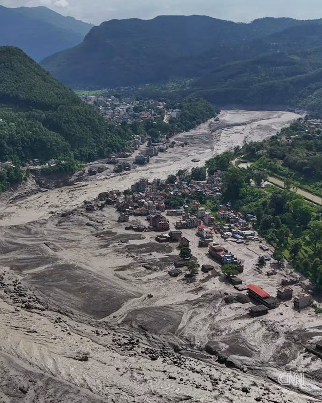
Kathmandu:- At least 350 people have been killed and nearly 1500 others are missing after a devastating flash flood and mudslide swept through the Nepal–Tibet border region on Wednesday, washing away settlements, roads, bridges and vital infrastructure.
The disaster struck the mountainous Rasuwa district, north of Kathmandu, when a sudden and powerful surge of water tore through the Bhote Koshi river system. Search and rescue operations are continuing on both sides of the border, with the Nepal Army reporting that 88 people have been rescued so far.
However, the scale of the disaster is still unfolding, with Nepalese authorities warning that casualties could rise significantly as communication remains disrupted and rescue teams struggle to reach isolated Himalayan communities.
What caused the devastating flood?
The exact cause has not yet been officially established, but preliminary assessments suggest that the disaster may have been triggered by a complex chain of geological and glacial events.
Scientists and officials are investigating whether a magnitude 4.4 earthquake in the Tibetan region, reported around the time of the disaster, triggered an ice-and-rock avalanche or landslide into the upstream Lhende river, a tributary linked to the Bhote Koshi system.
The avalanche may have temporarily blocked the river, causing water to accumulate behind the natural barrier. When the blockage failed or overflowed, the stored water could have been released suddenly downstream with enormous force, creating a destructive flash flood.
Experts are also examining whether a glacial lake outburst flood (GLOF) contributed to the disaster. The high Himalayan region contains numerous glacial lakes, and the area has experienced similar sudden floods in the past. Scientists have stressed that it may take several days of satellite analysis and field investigation to determine the precise sequence of events.
Why the Rasuwa region is highly vulnerable
Rasuwa lies in one of the most fragile parts of the central Himalayas, where steep mountain slopes, unstable rock formations, glaciers and narrow river valleys combine to create a high risk of flash floods and landslides.
Water released from an avalanche, landslide or glacial lake can move rapidly through these confined valleys. The steep gradient gives the flood tremendous destructive power, allowing it to carry rocks, trees, mud and debris downstream and turn a river surge into a catastrophic debris flow.
The region is also increasingly vulnerable to the effects of a warming climate. Himalayan glaciers are retreating, and the growth and instability of high-altitude glacial lakes have increased concern about sudden GLOF events. At the same time, intense rainfall and rapidly changing mountain weather can further destabilise already fragile slopes.
Importantly, Nepal’s Department of Hydrology and Meteorology reported that there had been no major rainfall in the Rasuwa area immediately before the disaster, strengthening the possibility that the flood resulted from a sudden upstream release rather than an ordinary monsoon flood.
Hundreds of tourists and travellers missing
The disaster has also created a major international search operation. Nepal’s tourism authorities were working to establish the whereabouts of 291 foreign tourists and 93 Nepalese nationals known to have been in the affected region.
The missing include travellers from India, the United Kingdom, the United States, Malaysia, South Africa and other countries. The area is an important transit route for travellers and pilgrims heading towards Tibet and the Mount Kailash region, increasing the number of foreign nationals caught in the disaster.
Roads, power projects and border infrastructure destroyed
The flood caused extensive destruction across Rasuwa and downstream districts, damaging or washing away homes, markets, roads, bridges and hydropower infrastructure.
On the Tibetan side, the disaster also affected the Gyirong border area, disrupting roads, communications and power connections. In Nepal, authorities issued alerts for communities along the Bhote Koshi and downstream river systems as floodwaters continued to move through the mountain valleys.
The destruction of roads has complicated rescue operations, while poor weather, high water levels and the difficult Himalayan terrain have restricted access to some affected communities.
Fear of a second flood
Authorities have warned that the danger may not yet be over. Reports indicate that an upstream blockage may still be present on the Lhende river, raising fears that another sudden release of water and debris could occur.
Communities downstream have been placed on alert, while authorities are monitoring the river system and urging people to avoid riverbanks and vulnerable areas. The risk of a secondary flood highlights the difficulty of managing disasters in high mountain environments, where unstable glaciers, landslides and natural dams can continue to pose threats long after the initial event.
A warning from the Himalayas
The Nepal–Tibet border disaster underlines the growing vulnerability of the Himalayan region to cascading disasters, where an earthquake, avalanche, landslide, glacial lake or river blockage can trigger a chain reaction with devastating consequences downstream.
While investigators are still determining the exact cause of Wednesday’s catastrophe, experts say the event demonstrates the urgent need for stronger cross-border monitoring of glaciers and glacial lakes, real-time earthquake and avalanche surveillance, satellite-based early warning systems and rapid information-sharing between Himalayan countries.
For Nepal and the wider Himalayan region, the disaster is another stark reminder that fragile mountain ecosystems can transform local geological or climatic events into major humanitarian crises within minutes.