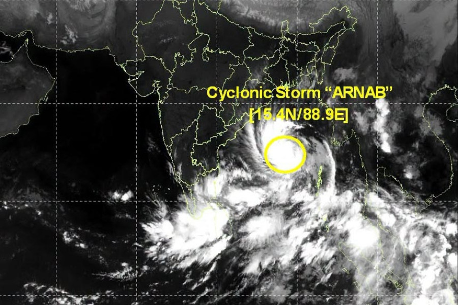
Extremely heavy rainfall, winds up to 140 kmph expected as Very Severe Cyclonic Storm approaches Andhra Pradesh and Odisha
VISAKHAPATNAM: Cyclonic Storm Arnab over the west-central Bay of Bengal will be intensified into ‘Very Severe Cyclonic Storm’ by the evening with wind speed of 125 kmph and gust reaching up to 150-160 kmph.
According to India Meteorological Department the Cyclone Arnab is expected to make landfall by the forenoon (before noon) of Wednesday, October 28, 2026, between Bapatla and Visakhapatnam, Andhra Pradesh, close to Yanam, bringing destructive winds and heavy to extremely heavy rainfall to several states, according to the latest cyclone bulletin.
The storm was centred over the west-central Bay of Bengal near latitude 15.9°N and longitude 85.4°E at 2.30 am IST on Tuesday, October 27. It was located approximately 300 km southeast of Visakhapatnam, 360 km east-southeast of Kakinada and 380 km south of Gopalpur in Odisha.
The system moved west-northwestwards at a speed of 25 kmph during the preceding six hours. According to the forecast, Cyclone Arnab is likely to continue moving west-northwestwards until the evening of October 27 before turning northwestwards.
It is expected to make landfall as a Very Severe Cyclonic Storm with maximum sustained winds of 115–125 kmph and gusts reaching 140 kmph. Red warning for Andhra Pradesh and south Odisha
A red alert has been issued for the Andhra Pradesh and adjoining south Odisha coasts as the cyclone approaches the coastline. The storm is being monitored continuously by the Doppler Weather Radar at Visakhapatnam.
Coastal Andhra Pradesh is likely to receive light to moderate rainfall at most places on October 27 and 28, with heavy to very heavy rainfall of 7–20 cm at a few locations. Extremely heavy rainfall of 21 cm or more is possible at isolated places on both days.
The government has intensified precautionary measures to protect lives and property. National and State Disaster Response Force teams have been deployed in cyclone-affected districts, while additional teams, rescue boats and tree-clearing units are on standby. Authorities have identified cyclone shelters, activated control rooms and appointed nodal officers to coordinate emergency operations. Twenty-seven crore rupees have been released for relief and preparedness measures.
People living in low-lying and at-risk areas are being shifted to safer places. Arrangements are being made for food, drinking water, medical care and sanitation at relief centres. Emergency teams are ready to restore electricity, clear roads and maintain essential services. Beaches have been closed, and fishermen have been advised not to venture into the sea. People have been urged to follow official warnings and safety instructions.
Rainfall is also expected to intensify across Odisha. South Odisha may experience heavy to very heavy rainfall at isolated places on October 27. On October 28, heavy to very heavy rainfall is likely at several places in south Odisha, with extremely heavy rainfall possible at isolated locations. North Odisha may also receive heavy to very heavy rainfall at isolated places. Odisha is also expected to experience significant weather impacts despite the forecast landfall being along the neighbouring Andhra Pradesh coast.
South Odisha is likely to receive heavy to very heavy rainfall at isolated places on October 27. On October 28, heavy to very heavy rainfall is expected at several places, with extremely heavy rainfall possible at isolated locations. North Odisha may also receive heavy to very heavy rainfall at isolated places.
The impact could extend into interior districts on October 29, when heavy to very heavy rainfall is forecast at isolated locations.
Heavy rainfall could cause localised flooding, disrupt transport and affect communities in low-lying areas. Authorities and residents in vulnerable districts need to remain alert as the cyclone approaches.
Several states braced for heavy rainfall
The impact of Cyclone Arnab is expected to extend well beyond the coastal districts of Andhra Pradesh and Odisha.
• Telangana: Eastern parts of the state may experience heavy to very heavy rainfall at isolated places on October 28.
• Chhattisgarh: South Chhattisgarh is likely to receive heavy rainfall at isolated places on October 27, followed by heavy to very heavy rainfall at several places and extremely heavy rainfall at isolated locations on October 28. North Chhattisgarh may face similar intense rainfall on October 29.
• Jharkhand: Heavy rainfall is likely at isolated places on October 28, with heavy to very heavy rainfall possible on October 29.
• Bihar: Heavy to very heavy rainfall is forecast at isolated places on October 29 and 30, with heavy rainfall continuing at isolated locations on October 31.
• West Bengal: Coastal districts of Gangetic West Bengal may receive heavy rainfall at isolated places on October 28 and 29. Sub-Himalayan West Bengal and Sikkim are likely to experience heavy rainfall at isolated places on October 29 and 30.
• Vidarbha: Eastern Vidarbha may experience heavy to very heavy rainfall at isolated places on October 28, followed by heavy rainfall at isolated locations on October 29.
• Andaman Islands: Heavy rainfall at isolated places was forecast for October 26, with rainfall expected to decrease thereafter.
With the cyclone forecast to bring intense rainfall and damaging winds to coastal Andhra Pradesh and adjoining Odisha, the approaching landfall poses a significant weather threat to the region. Residents in coastal and other forecast-affected districts should closely follow official weather bulletins and local administration advisories, particularly concerning heavy rainfall and strong winds.