


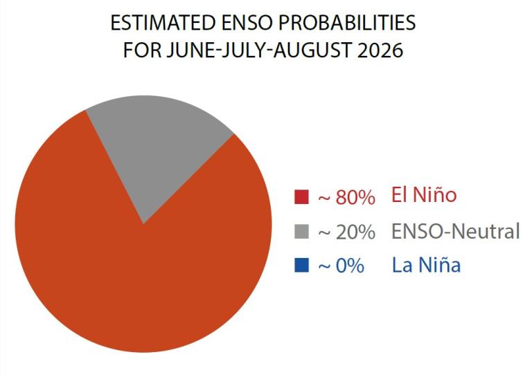
Geneva/New Delhi: The world is likely heading toward another significant El Niño event, with the latest update from the World Meteorological Organization (WMO), indicating an 80 percent probability that El Niño conditions will develop during June-August 2026 and a more than 90 percent chance that they will persist through at least November.
The assessment, based on forecasts from leading climate centres around the world, suggests the event is likely to be moderate to strong, potentially triggering widespread disruptions to weather patterns, agriculture, water resources, public health and energy systems across multiple continents.
Warning that El Niño could intensify the impacts of global warming, António Guterres, Secretary-General of the United Nations, said the phenomenon would “pour fuel on the fire of a warming world” and called for urgent climate action, stronger early warning systems and greater protection for vulnerable communities.
Scientists note that sea-surface temperatures in the central and eastern equatorial Pacific Ocean have been steadily rising and are approaching El Niño thresholds. Beneath the surface, temperatures are more than 6°C above average in some areas, creating a vast reservoir of heat that is feeding the warming ocean conditions. Atmospheric indicators, including the Southern Oscillation Index, are also showing signs consistent with a developing El Niño.
According to WMO Secretary-General Celeste Saulo, governments and humanitarian agencies need to prepare for heightened risks of drought, floods, marine heatwaves and record-breaking temperatures.
“We need to prepare for a potentially strong El Niño event – which will exacerbate drought and heavy rainfall and increase the risk of heatwaves both on land and in the ocean. The most recent El Niño, in 2023-24, was one of the five strongest on record and it played a role in the record global temperatures we saw in 2024,” said WMO Secretary-General Celeste Saulo.
“The WMO community will be carefully monitoring conditions in the coming months to inform decision-making by governments, humanitarian agencies and climate-sensitive sectors. Advance seasonal forecasts and early warnings are vital to save lives and cushion the impact on our economies and our communities,” said Celeste Saulo.
What El Niño Means: El Niño and La Niña are opposite phases of the El Niño–Southern Oscillation (ENSO); one of the most powerful naturally occurring climate patterns on Earth.
El Niño is characterized by a warming of ocean surface temperatures in the central and eastern Equatorial Pacific. It typically occurs every two to seven years and lasts around nine to twelve months.
It generally begins developing between March and June and reaches its peak intensity between November and February, with impacts on global temperatures typically being most pronounced in the second year after development.
Each El Niño event is unique in terms of its evolution, spatial pattern and impacts.
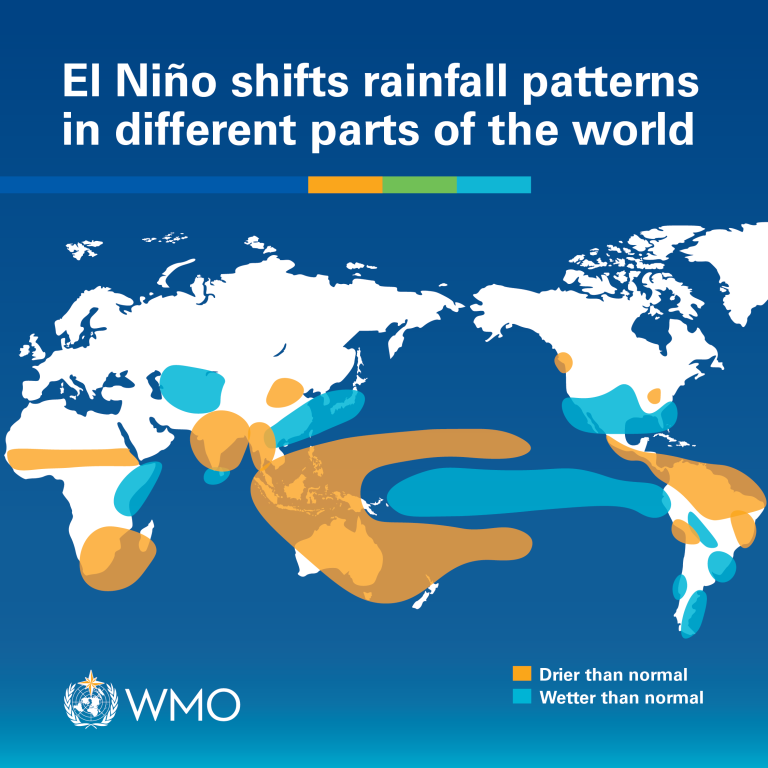
However, it is typically associated with increased rainfall in parts of southern South America, the southern United States, parts of the Horn of Africa and central Asia, and drier conditions over Central America, northern South America, the Caribbean, Australia, Indonesia, and parts of southern Asia.
Implications for India: The effects of each El Niño/La Niña event vary depending on the intensity, duration, time of year when it develops, and also how it interacts with other climate variability modes (such as the Indian Ocean Dipole). Not all regions of the world are affected, and even within a region, impacts can be different. Even when ENSO is neutral, extreme weather can still occur.
The strength of an ENSO event is highly significant, whether it is classed as weak, moderate, strong or very strong. Even a moderate El Niño makes some weather and climate extremes more likely.
WMO does not use the term “super El Niño” because it is not part of standardized operational classifications.
There is no evidence that climate change increases the frequency or intensity of El Nino events. But it can amplify associated impacts because a warmer ocean and atmosphere increases the availability of energy and moisture for extreme weather events such as heatwaves and heavy rainfall.
For India, El Niño is closely watched because of its influence on the southwest monsoon, which supplies nearly 70 percent of the country’s annual rainfall. While El Niño does not automatically mean a weak monsoon, many past El Niño years have been associated with below-normal rainfall, affecting agriculture, reservoir levels and food production.
Climate experts caution that the relationship between El Niño and the Indian monsoon has become more complex in recent decades because of other ocean-atmosphere influences, including conditions in the Indian Ocean. Nevertheless, a strong El Niño typically raises concerns over reduced rainfall, heatwaves and water stress in several regions.
Farmers, water managers and disaster-response agencies are therefore expected to closely monitor seasonal forecasts during the coming months.
Threat to Food and Water Security: The expected return of El Niño comes at a time when many countries are already facing climate-related stresses. Reduced rainfall in key agricultural regions could lower crop yields of staples such as rice, wheat and maize, potentially contributing to food inflation and supply disruptions.
Water shortages may intensify in drought-prone areas, while excessive rainfall in other regions could damage crops, infrastructure and transport networks.
The humanitarian impacts are often most severe in vulnerable communities that depend heavily on rain-fed agriculture and have limited capacity to cope with climate shocks.
Global Temperatures Could Rise Further: Scientists warn that El Niño could push global temperatures even higher after a string of record-breaking years. The previous El Niño event of 2023-24 was among the five strongest ever observed and contributed to unprecedented global warmth.
Combined with long-term human-induced climate change, the developing El Niño could increase the likelihood of new temperature records, more frequent heatwaves on land and in the oceans, and greater pressure on energy systems due to rising cooling demand.
The WMO said it will continue to monitor conditions closely and provide updated seasonal outlooks to help governments and climate-sensitive sectors prepare for the months ahead. Its complementary Global Seasonal Climate Update incorporates other climate drivers alongside El Niño, allowing for more detailed regional forecasts and early warning information.


